A drive from beachfront to mountain top in our northern beaches, deep forests and escarpment lookouts
Download the Scenic Drives map here.
View this Sea to summit scenic drive online here.
Our northern beaches are long wild stretches of untamed nature backed by dense coastal forests.
From seashore to mountain top, take a journey to see the northern beaches of the Barrington Coast then head high into Coorabakh National Park and surrounding state forests for a stunning contrast of deep forests, walks and lookouts.
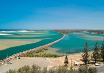
At the end of its journey from Barrington Tops, the waters of the Manning River flow languidly past Harrington into the Pacific Ocean. This historic seaside village is the perfect starting point for your discovery of the northern beauties of the Barrington Coast.
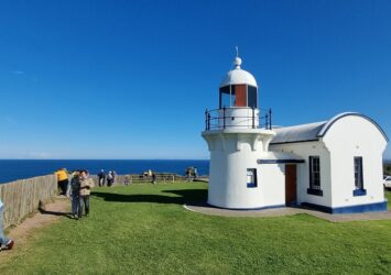
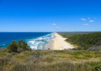
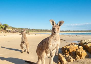
Just like our southern beaches, the beaches leading to our northern boundary are long wild stretches of untamed nature backed by dense coastal forests. The most famous of these is Crowdy Bay National Park which is home to Crowdy Head lighthouse and the friendly kangaroos on the beach at Diamond Head.
Also in this northern precinct, the state forests reach inland to the high escarpments of Coorabakh National Park. Studded with volcanic outcroppings, here you’ll explore sanctuaries for abundant wildlife, hidden waterfalls and several impressive lookouts across the splendor of the Manning Valley.
Points of interest
Harrington
Harrington is located where the Manning River meets the Pacific Ocean. In 1894 a long breakwall was built to protect the entry channel for shipping, which now it serves as a scenic walk and great fishing location. The nearby Pilot Hill Lookout provides expansive views over the river delta and the graves on the hill bear witness to the pilots whose task was to guide the boats over the bar.
Pilot Hill Lookout: The lookout is a grassed reserve on the site of the Pilot Station light beacon, lookout and signal house that operated at Harrington Beach in the late 1800s. The site includes an information display and a replica of the signal house flagstaff. Nearby are graves associated with the Pilot Station dating back to 1875. The actual pilot station was located where the Post Office stands today (in Pilot Street between Beach and Hedges Street) just up from Harrington Beach. Enjoy spectacular views of the Manning River backchannel and breakwall. The area is part of the Harrington Beach State Park covering 431 hectares stretching between Harrington and Crowdy Head.
Crowdy Bay National Park
At the far northern boundary of the Barrington Coast sits Crowdy Bay National Park featuring rugged coastline cliffs, rockpools, beaches and forests which are a haven for wildlife. The park’s main topographical feature and highest point is Diamond Head, which rises abruptly to 113 metres. It takes its name from the quartz crystals that are found in the area.
There are a number of great, well-appointed camping grounds that lie within the park including Crowdy Gap, Kylie’s Beach, Indian Head and Diamond Head. Make sure you take advantage of the many picnic areas and keep your eyes peeled for the resident friendly kangaroos who will hop right up to you and onto the beach!
1. Crowdy Head Lighthouse: North of Harrington is the small fishing village of Crowdy Head which retains evidence of its European settlement and history around the area with a strong maritime flavour. The iconic Crowdy Head Lighthouse is provides 360-degree views of the coast. Between May and August, keep your eye out for passing humpback whales. The lighthouse itself is picturesque and a great place for a photograph as well as being easily accessible on a sealed road.
2. Kylies Beach: This wild remote beach is named for Australian author Kylie Tennant who once lived in Laurieton and had a rustic writer’s retreat hut here. Unfortunately the hut was destroyed in the November 2019 bushfires that devastated this area.
3. Kylies Beach Campground: This campground offers quiet beachside campsites for caravans, trailers and tents.
Johns River
The village of Johns River is located ironically on the Stewarts River which rises on the northern slopes of Big Nellie within Coorabakh National Park, west of the village of Hannam Vale.
Hannam Vale
Nestled between three National Parks is the pretty village of Hannam Vale, which is free from the hustle and bustle of daily life. Visit the local General Store for refreshments, directions and a good ole country chat. Over the summer months, you can pick up some of the juiciest berries straight from the fields of the local berry farm.
Coorabakh National Park, Comboyne State Forest and Lansdowne State Forest
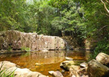
1. Waitui Falls: Tucked away in the middle of the forest on the border of the Coorabakh National Park, Waitui Falls makes the most delightful family picnic area; swimming in the waterhole is generally safe though young children must be supervised by adults.
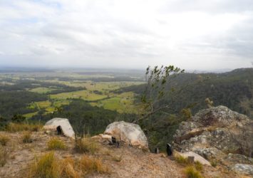
2. Flat Rock Lookout: Flat Rock is a beautiful rock formation, remnant of a vast volcano that once dominated Comboyne Plateau to the west. A small fenced viewing platform opens out over sweeping plains. On clear days, the Coxcomb, Goonook and Killabakh nature reserves are visible far into the distance, laid out like a green and yellow patchwork of dense blackbutt forests and grassy fields.
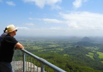
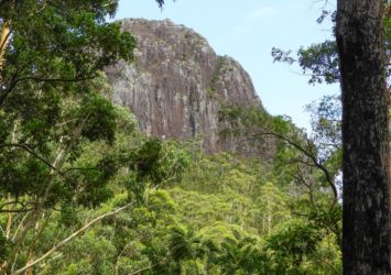
3. Big Nellie Lookout: This lookout is one of the main attractions of Coorabakh National Park. It’s an imposing rock plug that soars more than 500m above sea level, reminding visitors of an earlier time when the Australian landscape was still being created by volcanoes and earthquakes. The best place to see scenic Big Nellie is right near its base, where a handy platform has been built to give clear views over the rocky hump. Near the lookout are several tables, making this a good place as a place to picnic as well.
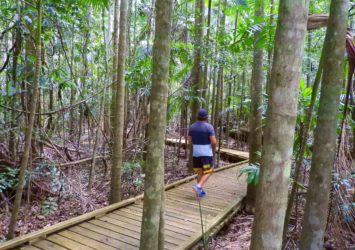
4. Starrs Creek Walk: The sheltered picnic area hidden in the forest is the perfect place to enjoy the splendour of the rainforest, with light filtering through the canopy into a cool clearing. It's also the access point to a beautiful elevated boardwalk, perfect for walking with children and fully wheelchair-accessible. This easy 400m stroll threads through unusual palms and other subtropical species popular with the local animals, some of them threatened.
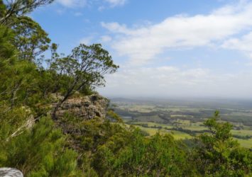
5. Newbys Lookout: One of several great lookouts in Coorabakh National Park, Newbys Lookout is perched on the edge of the sandstone Landsdowne escarpment, with stellar views over the flat expanse of Manning Valley. A wooden ramp leads up to the lookout, making it accessible to everyone. There are tables available offering a great picnicking opportunity before heading to the park’s other attractions and vantage points over the surrounding landscape.
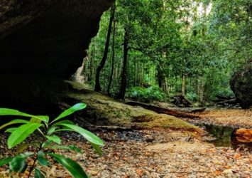
6. Newbys Cave: Five minutes walk up the creek from Newbys Creek Road, you can explore the fascinating Newbys Cave. The cave has a large overhanging rock formation, making a natural shelter in the creek bed. The walk continues further upstream amongst lush ferns and sparkling creek waters. Stuttering frogs hide among the lush ferns that border this crystal clear stream. Take off your shoes and shuffle along a creek bed that threads through dense subtropical foliage and moss-covered rocks. Newbys Cave is just five minutes from the road, but feels kilometres away.
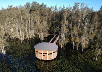
8. Cattai Wetlands: These wetlandsprovide a sanctuary for over 180 species of birds, kangaroos, wallabies and regularly spotted goannas. Make your way along one of the many walking tracks, go bird watching, take a picnic or just relax and enjoy the scenery. Cattai Wetlands is open to the public 7 days, from 8am to 3pm Monday to Friday and 7am to 5pm on Saturday and Sunday. Guided tours are also available by appointment – call MidCoast Council on 02 6592 5399. No dogs are allowed in the wetlands.