You'll need several drives to explore all the world heritage wilderness of Barrington Tops.
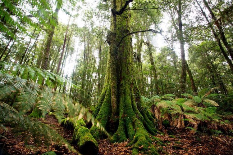
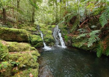
At the highest point of the Barrington Coast you’ll find trails leading to ancient forests, mossy cascades, lookouts across endless green and even snow in winter.
Download the Scenic Drives map here.
View this Barrington explorer scenic drive online here.
If you're heading to Barrington Tops the best approach is via Gloucester on the eastern side, stop for fuel, provisions, a coffee or a meal on your way through.
Barrington Tops is big - really big - so you need to decide which precinct you’d like to start with.
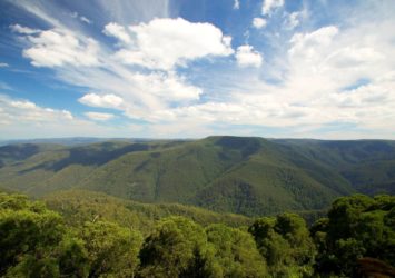
The Barrington Tops parklands is a collection of national parks, state conservation areas and state forests at the highest point of the Barrington Coast. Together they total almost 125,000 hectares of wilderness. That’s 1,250 square km to lose yourself in, so take care when venturing into this beautiful region…. it has swallowed planes and people without a trace. And it’s also hidden bushrangers and fugitives for years.
How big?
- Barrington Tops National Park (northern precinct accessed via Gloucester; eastern precinct of Gloucester Tops accessed via Gloucester): 76,500 hectares
- Barrington Tops State Conservation Area (northern precinct, accessed via Gloucester): 8,400 hectares
- Barrington Tops State Forest (northern precinct, accessed via Gloucester): 14,000 hectares
- Chichester State Forest West (Allyn River) and Chichester State ForestEast (Telegherry River) (southern precinct, accessed via Stroud): 15,000 hectares
- Stewarts Brook State Forest (western precinct, accessed via Gloucester): 3,800 hectares
- Mount Royal National Park (south west precinct, accessed via Singleton): 6,900 hectares
Total = 124,600 hectares
So now that you know Barrington Tops is big - really big - you'll need to decide which precinct you’d like to start with. Choose your destination to choose your scenic drive: northern, eastern or southern precincts of this beautiful remnant of ancient Gondwana.
As a rough guide, you need the following time as absolute minimum to explore and enjoy each precinct:
- Northern: one day
- Eastern: half day
- Central:multiple days whether on foot or in 4WD
- Southern: one day west, half day east and one day if walking the Corker Trail to Careys Peak
- South western: half day but one day if walking Pieries Peak
Points of interest in the northern precinct
Copeland Tops State Conservation Area
1. Hidden Treasure Walking Track: From the carpark this 4.5 km track offers an easy two hour return walk through dry rainforest to the Hidden Treasure mine precinct along Copeland Creek. Here you can see relics of the area’s gold mining history.
2. Basin Loop Walking Track: This walk continues on from the Hidden Treasure track and continues along Old Copeland Road for a 7 km loop walk that takes 4 hours return. You’ll walk through dry rainforest and into open forests on the ridges before returning back down into the mossy and dark Copeland Creek gully.
3. Copeland Hidden Treasures: Join a guided tour through the heritage gold mining precinct now protected by NPWS. Wander through rainforest gullies on timber boardwalks, get up close to the workings of a heritage goldmine, touch the mossy landscapes and unlock the secrets of bush tucker. Tours operate seasonally, bookings are essential at Gloucester Visitor Information Centre, call 6538 5252.
Barrington Tops
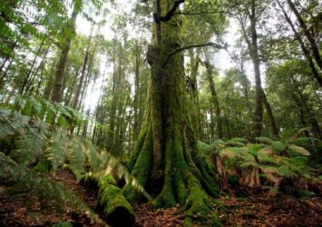
1. Honeysuckle Walking Track: From the Honeysuckle Picnic Area take the track for an easy 1 km 30 minute walk. The sheltered track loops through magnificent Antarctic Beech forest and towering tree fern groves where it’s easy to imagine dinosaurs roaming through this ancient landscape.
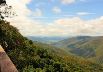
2. Devils Hole Lookout: A paved path from Devils Hole Picnic Area provides an easy 100m walk suitable for wheelchairs and strollers. The lookout offers spectacular outlook across the Barrington Tops wilderness and on a clear day you can see the Barrington coastline 90 km to the east.
3. Thunderbolts Lookout: From the parking area, a short flat track takes you 200m through snow gum woodland to the edge of the escarpment. The spectacular view reveals the deep valley of the Moppy River below and Mount Carson beyond.
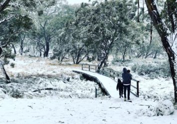
4. Polblue Picnic Area and Campground: Next to the Polblue Swamp wetlands is Polblue Camping Area which is the highest campground in Australia that you can drive to. The Polblue Swamp Track explores these high altitude wetlands on an easy 3 km stroll. The loop track starts at either the Polblue Picnic Area or the Polblue Camping Area just across the timber walkway that straddles Polblue Creek. This place is especially beautiful in snow.
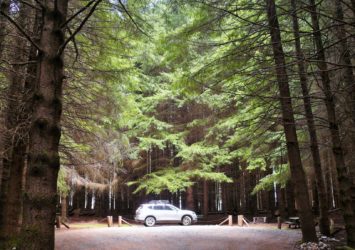
5. The Firs Picnic Area: Located in the Stewarts Brook State Forest precinct of Barrington Tops near the Dingo Gate, this picnic area is hidden in the eerie darkness of an old Douglas fir plantation. You’ll feel like you’re in Vancouver until you see the resident lyre birds and hear their amazing range of bird call mimicry.
6. The Dingo Gate: An interesting bit of early rural protection infrastructure, from back in the days when fences and walls were the only answer.
7. Polblue Falls: Rarely visited, there's a small picnic area and a path to an observation point overlooking the waters of Polblue Creek tumbling down the falls.
8. Gummi Falls: Where the Manning River is born, at a remote campground accessible only by 4WD.
9. Aussie Ark: The world famous wildlife conservation facility that's preserving endangered Australian animal species: Tasmanian devil, Eastern quoll, Parma wallaby, Rufous bettong, Manning River turtle, Brush tail rock wallaby and long-nosed potoroo.
Points of interest in the eastern precinct:
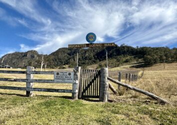
1. Gloucester Bucketts Scenic Walk: This scenic walk to the base of the Buccan Bucccans overlooking Gloucester is not an easy walk but it provides ample rewards: panoramic views of the Gloucester valley, a rich array of flowering plants, wildlife and wonderful photo opportunities.
Gloucester Tops
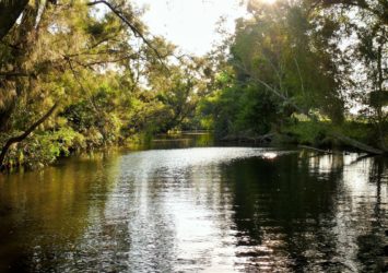
2. Gloucester River Walking Track: This 2.5 km track takes you on a one hour walk. It starts at the road bridge across the Gloucester River just downstream from the camping area. The walks follows the river upstream through diverse and vigorous young forest. You can choose to wade across the river to join Gloucester Tops Road as your return route to the camping area, or you can return the same way you came.
3. Sharpes Creek Walking Track: Like the Gloucester River track, this walk can be done as a return walk or a loop, through dark and lush rainforest. Choose the easy 3 km track for a one hour return walk up Sharpes Creek or the harder 4.5 km loop walk that returns to the camping area via Gloucester Tops Road.
4. Antarctic Beech Forest Walking Track (short walk or long walk): Step behind a green curtain into a world of dark temperate rainforest with ancient Antarctic beech trees, towering tree ferns, moss covered logs and sparkling cascades. Choose the 1 km track for a 20 minute walk or the 2.5 km track for a 90 minute walk.
5. River Walking Track: From the carpark opposite the Antarctic Beech Track follow this 2.5 km loop track for an easy one hour walk along the upper plateau sections of the Gloucester River before it plunges over the escarpment.
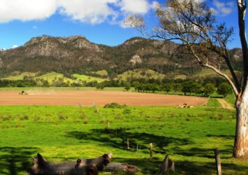
6. Andrew Laurie Lookout: Take the Gloucester Falls Track from the picnic area for an easy 1.5 km one hour walk. This walk takes you via Andrew Laurie Lookout perched on the edge of the escarpment. On a clear day the vista includes the deep gorge of the Gloucester River to distant farmland across ridges to The Mountaineer peak.
7. Gloucester Falls: Continue along the Gloucester Falls Track from Andrew Laurie Lookout to Gloucester Falls. There is a new viewing platform near where the river begins its 400m plunge off the plateau. The track continues upstream to the series of cascades that comprise Gloucester Falls, take extreme care on the rocky banks, especially after rains when the river will be up.
Points of interest in the central precinct (seasonally closed to 4WD vehicles)
Points of interest in the southern precinct
Barrington Tops and Chichester State Forest
- Blue Gum Loop Walking Track: From the Williams River picnic area this popular 3.5 km loop track explores riverside forests & subtropical rainforests. The first section to the bridge over the river is accessible to wheelchairs. Allow 1.5 hours for this relaxed walk.
- Rocky Crossing Walking Track: This extended version of the Blue Gum Loop Track is ideal for a more challenging walk that rewards you with a pretty waterfall in a beautiful setting. Allow 6 hours for the 16 km return walk.
- Ladies Well: Located in the Chichester State Forest of Barrington Tops, this is a very picturesque waterhole with cascades. It is very popular in summer for swimming, where you can relax on warm rocks or take a dip in the icy cool waters of the Allyn River.
- The Corker Walking Track: This walk is only for those seeking a challenge on this long steep climb from the Lagoon Pinch picnic area. You'll head for Careys Peak high on the Barrington Tops plateau. It's a serious 20 km return walk taking around 10 hours. The reward is a spectacular lookout from Careys Peak. The track also connects with other high walking trails on the plateau.
- Careys Peak: One the best lookouts within Barrington Tops, a big reward for the massive effort to get there on foot or mountain bike.
- Mount Allyn Lookout: A spectacular lookout with 360 degree views of the forests, park and wilderness. The return distance from the main road is 28 km.
- Jerusalem Creek Walking Track: A lovely stroll for those visiting the Jerusalem Creek picnic area off Wangat Rd to the east of Chichester Dam. An easy 4 hour walk, 4 km return.
Points of interest in the south western precinct
Mount Royal National Park
Pieries Peak: Pieries Peak walking track is a short climb from Youngville campground to the peak. The track follows a narrow and rocky ridge with steep sides. It's not for the faint-hearted but you'll be rewarded with sensational views across the Hunter Valley. It's 3 km return but allow up to 2.5 hours.